Non Precision Approach Page 7
FMC Approaches
If your aircraft is FMC equipped and capable of VNAV (Boeing) or managed approaches (Airbus) then you may elect to fly the procedure in LNAV/VNAV. As I am not familiar with Airbus operations I will comment only on the Boeing procedure.
Have a look in your data base and see if there are any approaches available for NZNR (these are called Canned approaches). If there is then that is great. Select the approach followed by the arc transition if available. Chances are that there won’t be an arc and probably not an approach either. No problem we can construct an approach on the legs page ourselves.
Let’s stick with our NZNR scenario starting with the arc.
As we are tracking between Taupo and Napier our legs page and ND (Nav display) should be indicating the NR VOR as the active waypoint.
We know that we are on the NR298 radial and that we will need to track around a 10 mile arc.
Let’s enter this arc intercept point as a waypoint.
We can do this in 2 ways:
As an along track waypoint. Type in NR/-10 into the scratch pad and select this over NR (not below it. It must be entered on the same line as NR.)
As a place/bearing/distance waypoint. NR298/10 (This would be entered under NR.)
This will give us the waypoint at which we want the aircraft to initially track to before commencing the turn onto the arc.
Building the arc
We do this by creating a series of place/bearing/distance waypoints based on the NR VOR that will approximate the arc. Ideally these points should not be further than 10 degrees apart.
We have our first point on the arc at NR298/10.
The last one will be at NR005/10 which is on the inbound final approach course.
So if we apply 10 degrees between each one our legs page entries should be:
NR/-10 or NR298/10
NR308/10
NR318/10
NR328/10
NR338/10
NR348/10
NR358/10
NR005/10
This creates a whole series of points around the arc that the LNAV will track. LNAV will also calculate the lead it needs to turn onto the arc so we do not need to factor this into the first waypoint.
Now to build the approach
The first waypoint on the approach is the last one on the arc; NR005/10. This is the initial approach fix.
The next point I would put in is the final approach fix which is at 5 NR DME
Enter NR005/5
The next point would be NR. You could put the MAP point and then the 16 RW fix (if present and this would have to be selected on the DEP/ARR page as 16 in the approach options - runway) although I think you will find that LNAV will lead this point and track to the runway threshold too early. It will not be possible to build the missed approach and have VNAV follow it. It will only do this with a canned approach where it is already coded within the program.
In order to prevent getting an “END OF ACTIVE ROUTE” message put in a way point at say 5 nm past the NR VOR. This means that approaching the NR VOR you wont get the message and LNAV and VNAV will stay engaged and not revert back to the defaults of HDG HOLD and ALT HOLD.
Once we have these waypoints entered we can check it using the plan mode on the EFIS control panel to check for any irregularities of track etc.
Once we are happy with the plan view we can enter some altitude constraints.
The first on the arc is where we intercept it. We cannot be below the route MSA here so we can place an alt constraint of say at or above 6500ft. We also have said we want to fly the arc at 210 kts so lets enter 210/6500A against our first arc waypoint. The A stands for at or above.
The next restraint is that we cannot go below 3700ft until after crossing the NR315 radial. We have a waypoint at NR318/10. As 318 is so close to 315 why not change this waypoint to NR315/10 and then enter 210/3700A next to it.
The next point is not below 3300 ft until crossing the NR345 radial. As this is so close to the charted inbound altitude of 3200 ft at 10 nm I would not bother with this one but you could modify the NR348/10 waypoint to NR345/10 and enter 210/3200A against it.
The altitude we can now descend to is 2700ft until on final. We could put this alt against the first point on the final approach as well as the airspeed we want to fly the initial approach at (say 180 kts)
So against the NR005/10 waypoint we could put 180/2700A and this would let VNAV decide what altitude it wanted to cross the intial approach fix at.
This is OK but I would much prefer to lock in that 3 degree slope from this point so instead I would put:180/3300
The next constraint would be the final approach fix at 5 nm.
Against the NR005/5 waypoint I would put say:160/1700
The next one depends on whether or not you entered the MAP point.
If you did then against the NR005/0.6 waypoint you would add
VREF/0400 (VREF would be your nominated landing speed)
If you didn’t enter the MAP then you would need to work out what altitude you would need to be at the NR VOR at in order to maintain the 3 degree slope.
We know from looking at the approach chart that at the MAP we will be 0.6 from the VOR at an alt of 400ft. Therefore multiply 0.6 x 3 to get the height need to lose from 400 ft in order to continue down at 3 degrees. ) 0.6nm X 3 = 180ft
Therefore 400-180=220.
So over NR we would put TTS/0220 (TTS = VREF + half steady headwind component and all the gust value to a min of 5 kts and a maximum of 20 kts)
So if the wind was 160/20 gusting 30 we would add to VREF half of 10 which is 5 plus 10 which is the gust factor (difference between steady wind and the gust value.) So if our VREF was 140 kts our TTS would be 140 + 15 = 155 kts.
This all might sound rather difficult but I am also trying to explain the reasons for doing it and the theory involved. Make the numbers easy for yourself. After a while it becomes second nature and you can build up approaches very easily.
You can now sit back and watch LNAV fly the approach for you!
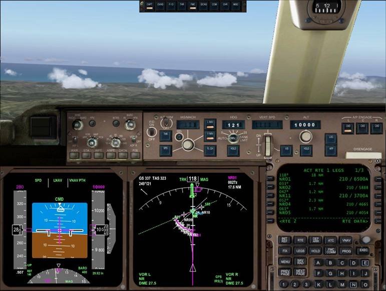
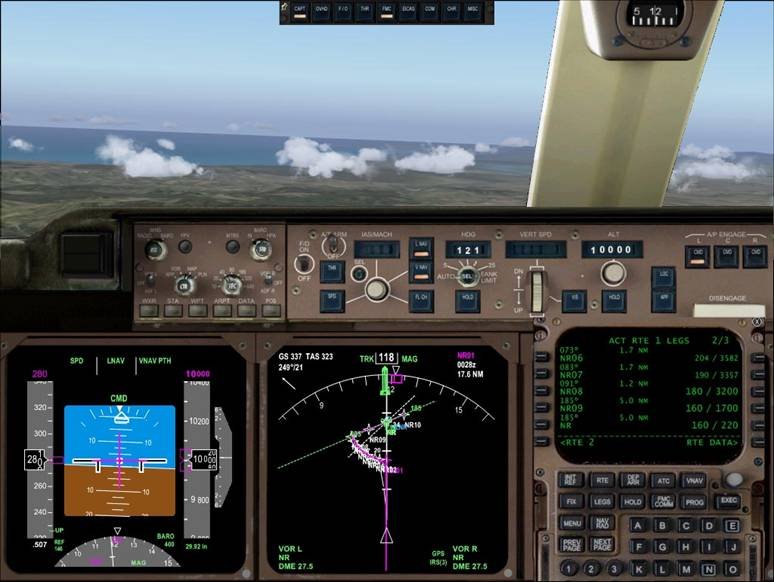
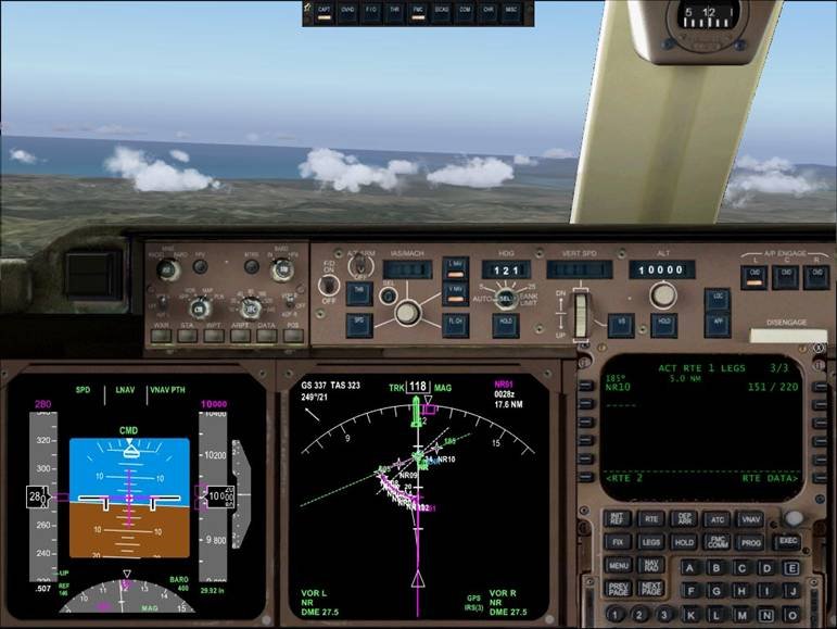
Our FMC legs page should look something like this:
 Here is page 1 of 3 legs pages. NR01 is the start of the arc. At the moment the MCP alt is set to cruise alt.
Legs page 2. This shows the waypoints on final.
Legs page 3. Here I have entered a point 5 miles past the VOR at 220 ft. This stops the end of route activating and going to heading hold. Having the same alt as the NR crossing altitude will allow the aircraft to keep descending. If this were set higher then when the active waypoint cycles from NR (which is does about .7 nm before the NR VOR) the aircraft would be trying for the altitude at that point rather than continuing on down.
<< Prev Page - Next Page >>

